/PROJECT · in-progress
Spatiotemporal Deep Learning for Wheat Rust Detection Using SAR–Optical Satellite Data
Detecting wheat rust from radar and optical satellite time series, with an evaluation built to catch shortcuts and leakage.
On this page
Overview
Wheat rust is hard to monitor at scale. The only public ground truth is district and village-level text in ICAR-IIWBR surveillance newsletters, not pixel labels. Labels are scarce, and a model can look accurate by learning a shortcut such as the date or the location. The project asks whether a model built for this data can match a re-implemented state-of-the-art benchmark using fewer labels, and it sets up the evaluation so the answer can be checked.
How it works
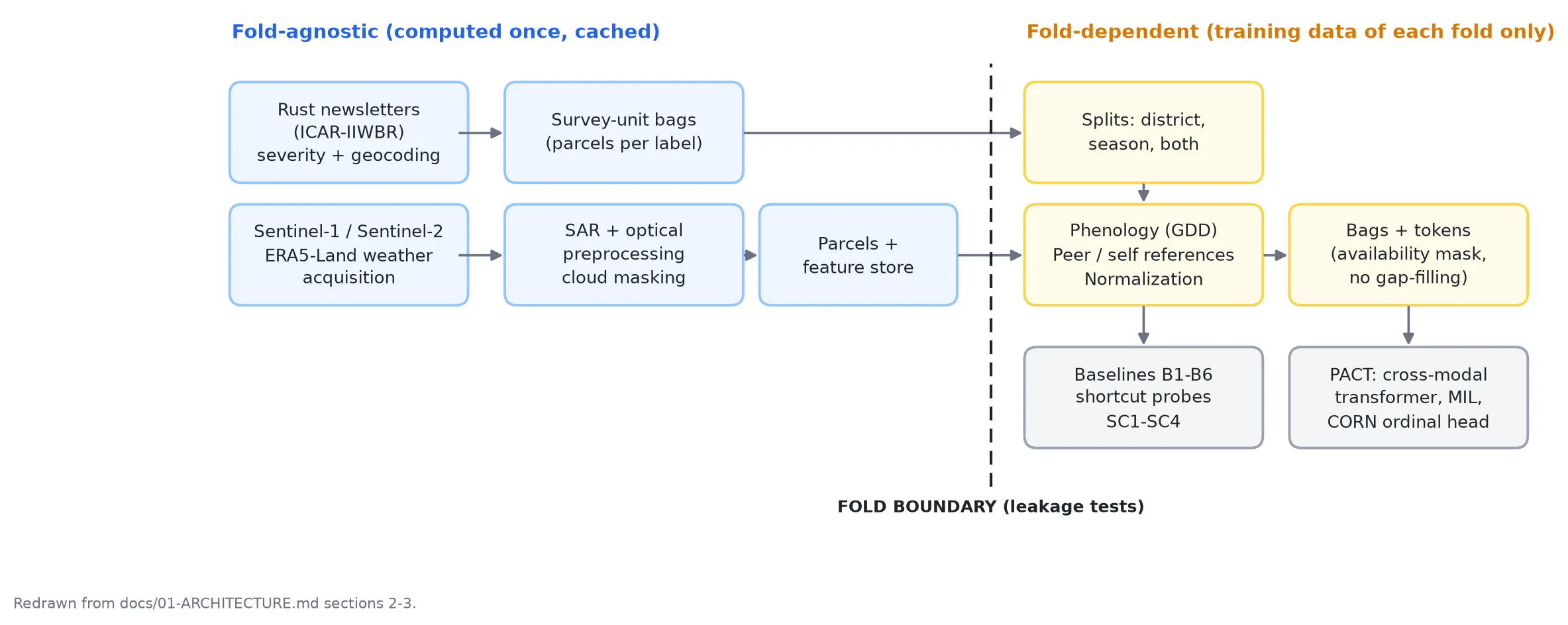
A staged batch pipeline, run by eight numbered scripts in scripts/:
- Extract and normalize rust severity from newsletters, then geocode survey units.
- Acquire Sentinel-1/2 scenes (Copernicus STAC, with a Google Earth Engine path for the pilot) and ERA5-Land weather.
- Preprocess SAR and optical imagery, build parcels and a per-parcel feature store.
- Build spatial and temporal splits, then train and evaluate.
A hard boundary separates fold-agnostic steps from fold-dependent ones. Wheat masks, phenology fits, neighbour references and normalization statistics are computed per fold from training data only, and tests/test_leakage.py checks this. The PACT model is a two-stage cross-modal transformer with continuous-time attention, a gated-attention multiple-instance pooling layer and an ordinal (CORN) severity head. Observations are never gap-filled; an availability mask is used instead.
inputs: Sentinel-1, Sentinel-2, ERA5-Land weather
labels: village-level, from ICAR-IIWBR surveillance newsletters
encoder: two-stage cross-modal transformer
time: thermal time (GDD) positional encoding
pooling: gated-attention multiple-instance learning
head: ordinal (CORN) severity
tracking: Hydra, MLflow, Optuna
Where it could break
| Theme | Risk | Check |
|---|---|---|
| leakage | Train/test leakage | Wheat masks, phenology fits, neighbour references and normalization statistics are computed per fold from training data only, and tests/test_leakage.py audits each fold. |
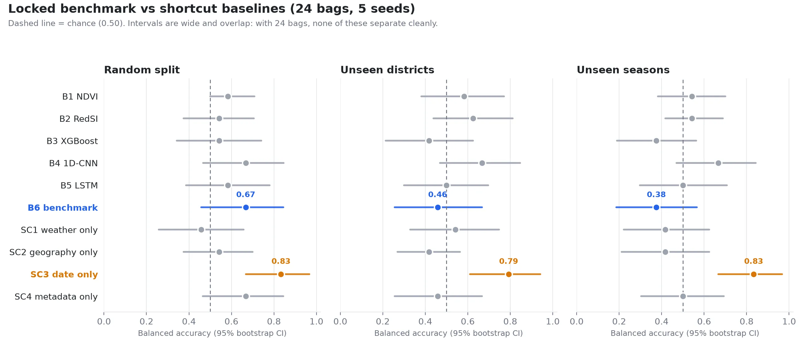
| shortcut learning | A model looks accurate by learning the date or the location | Four shortcut probes (weather, geography, date, metadata) and a shortcut-audit verdict. A date-only shortcut scored 0.79 and 0.83 balanced accuracy, against 0.49 and 0.47 for the re-implemented benchmark (B6) under spatial and temporal holdout. |
| data integrity | Missing satellite observations filled with invented values | Observations are never gap-filled. The model gets an availability mask instead. |
| evaluation | Conclusions drawn from too few samples | Paired bootstrap and McNemar tests, with intervals reported (they are wide with 24 bags). The benchmark is locked with a git tag and a hashed manifest. |
| reliability | A risk map shown without its uncertainty | The risk-map export (GeoPackage, GeoTIFF) refuses to write without uncertainty and a reliability mask. |
Key features
- Irregular-sampling-native encoder with thermal-time (GDD) positional encoding.
- Multiple-instance learning over parcels, with per-parcel attention used as a risk map.
- Baselines B1-B6 and four shortcut probes (weather, geography, date, metadata).
- Ablations A1-A12 switched by config files.
- Pre-registered protocol, with amendments recorded as dated entries.
- Shortcut-audit verdict, paired bootstrap and McNemar tests, and a risk-map export (GeoPackage, GeoTIFF) that refuses to write without uncertainty and a reliability mask.
Highlights
- Built a 20,000-line Python package (
src/pact, 19 subpackages) covering ground truth, SAR/optical preprocessing, phenology, splits, models, training and inference. - Wrote 92 test files with 1,046 test functions, including leakage audits for each fold, run in GitHub Actions with ruff, mypy and pytest.
- Implemented a two-stage PACT transformer with gated MIL pooling and a CORN ordinal head, plus a re-implemented benchmark (B6) and four shortcut baselines.
- Locked the benchmark with a git tag and a hashed manifest. B6 averaged 0.49 and 0.47 balanced accuracy over 5 seeds under spatial and temporal holdout, against 0.79 and 0.83 for a date-only shortcut. With 24 bags the intervals are wide.
- Documented 28 architecture decisions and a frozen experiment protocol, and ran GPU experiments with Optuna search on rented A40 nodes.
Tech stack
- Language: Python 3.11
- ML: PyTorch, scikit-learn, XGBoost, Optuna
- Geospatial: rasterio, GeoPandas, shapely, pyproj, xarray, rioxarray, pystac-client, earthengine-api, cdsapi
- Data and config: pandas, PyArrow (Parquet), Hydra, OmegaConf, MLflow
- Deployment and compute: no deployed service; training ran on rented E2E A40 GPU nodes
- Tooling: uv, hatchling, pytest, ruff, mypy, pre-commit, GitHub Actions
/Stack
- Python
- PyTorch
- Hydra
- MLflow
- Optuna
- XGBoost
- scikit-learn
- pandas
- PyArrow
- rasterio
- GeoPandas
- xarray
- Google Earth Engine
- GitHub Actions
- uv